NASA has aborted the launch of the CYGNSS micro-satellites following an anomaly with the rocket release system.
NASA has aborted the launch of the CYGNSS micro-satellites following an anomaly with the rocket release system.
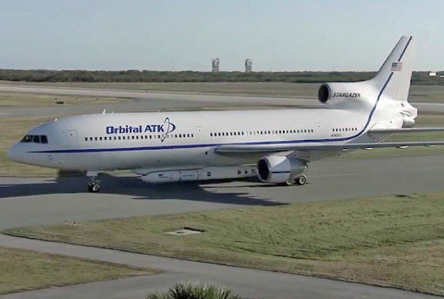
The Orbital ATK “Stargazer” L-1011 aircraft took off from the Skid Strip at Cape Canaveral Air Force Station in Florida, carrying the company’s Pegasus XL rocket attached to the belly, containing the eight CYGNSS microsatellites.
The Orbital ATK Pegasus XL rocket was to be released from the aircraft at its drop point 39,000 feet above the Atlantic Ocean.
NASA Launch Manager Tim Dunn of the Launch Services Program said the hydraulic pump that controls the release of the Orbital ATK Pegasus XL rocket from the L-1011 carrier aircraft developed an problem en route, after takeoff, in the last 25 minutes prior to the initial 8:30 a.m. launch time.
Due to a hydraulic issue & weather concerns, the 8:40am ET #CYGNSS launch attempt bypassed. Looking at 2nd pass. https://t.co/CmwKwbsr2D pic.twitter.com/INPEgbrxcF— NASA (@NASA) December 12, 2016
“The team did a lot of valiant troubleshooting in the air,” Dunn said. “Everyone wanted to have another launch attempt today, so we continued right up until the L-4 minute point.”
Weather also posed problems at times during the countdown, Dunn pointed out.
“The pilots flew around, under and over a lot of precipitation and bad clouds,” he said.
The next possible launch opportunity is Tuesday, pending resolution of the pump issue the Cyclone Global Navigation Satellite System mission to fruition.
CYGNSS will utilize a constellation of eight microsatellite observatories that will be placed in a circular orbit more than 316 miles above the Earth’s surface. With an orbital inclination of 35 degrees, the small spacecraft will concentrate on the region nearest the equator — the tropics — where these cyclones form.
Once fully deployed, each CYGNSS microsatellite will weigh close to 64 pounds and measure about 5.4 feet long by 1.7 feet wide, and a depth of about three quarters of a foot.
The Delayed Doppler Mapping Instrument (DDMI) installed on each satellite will provide wind-field imagery of the formation, intensification and decay of tropical cyclones in unprecedented detail. The DDMI also allows the CYGNSS observatories to receive signals from GPS satellites as well as signals reflected off the ocean’s surface.
The CYGNSS mission is planned to last at least two years, the minimum design life of the microsatellites.


